With changing uses over the centuries, there’s a variety of traces of the past along the shore and out in the bay. Have a look at some Fleetwood beach landmarks. Have you got any more to add?
Fleetwood Beach Landmarks
Fleetwood beach is at the bottom of Morecambe Bay. With a wide tidal range and the channel into the River Wyre it’s been an important site for fishing, trade and traffic for many centuries. These activities of our ancestors leave things behind. Interesting glimpses into the past…
If you’ve found something unusual, please email to jane@theRabbitPatch.co.uk We’ll publish them here for you to identify!
Rossall Landmark Fleetwood
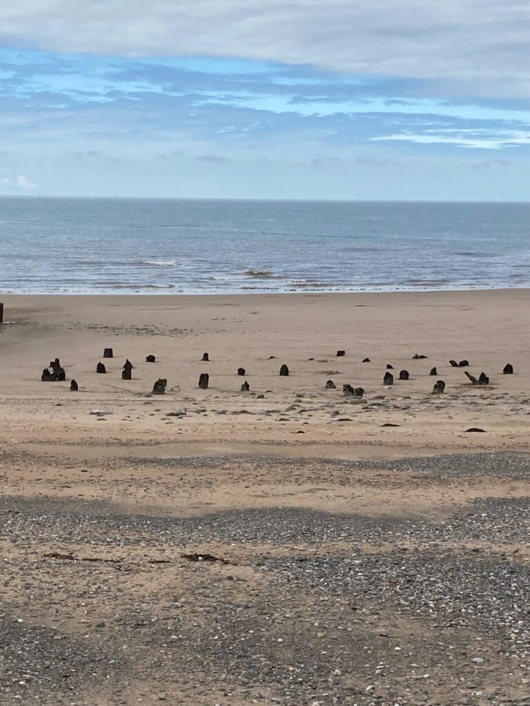
Have you ever noticed a set of stumps, sticking up out of the sand near Rossall Tower? They’re the remains of Fleetwood Beach Landmark – a navigation marker to guide ships into port. You might hear it called the beacon too. Thanks to Jill Cooke for the next photo.
According to the Red Rose Collections website, Rossall Landmark was a navigation point off Rossall at Fleetwood guiding shipping entering the Lune Deeps. This version was pulled down in 1929, but the structure’s mentioned in the Domesday book of 1086.
What was it?
Every few months someone sends us a photo of these intriguing stumps, asking what they are. Clearly visible most of the time, they’re about hundred yards from the promenade, five sets of breakwater down after the observation tower in line with the wooden steps that take you over the sea wall to the bridle path. So we thought we’d try to find out more!
FREE Newsletter
FREE Newsletter

George Booth came up trumps with some really interesting information in response to us asking the question on Facebook. He tells us: “The remains of the last Landmark are still visible today, alongside groyne 56 near Rossall Point watchtower.
Never underestimate the power of the sea!
“The Landmark had a very chequered history. The first one was completed on 17 June 1767. Unfortunately it was done on the cheap, only to be replaced by another one, completed on 14 July 1768. This structure didn’t last much longer and was replaced in 1778. And again in 1783! So bad was the damage then, it was decided to replace it with a stone structure 24 feet diameter at the base and 12 feet diameter at the top. The committee then changed their minds and kept with the wooden structure.
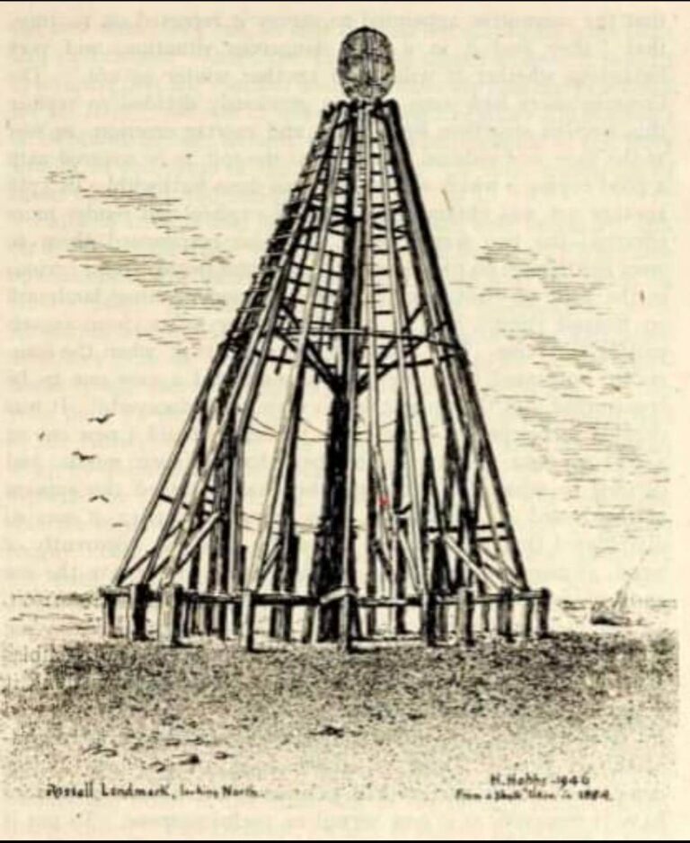
“The commissioners responsible for the Landmark really should have chosen their contractors with a bit more due diligence! By 1847 the latest wooden tower was crumbling and so was once again replaced by another wooden tower. It was decided that it looked like a ship in full sale from a distance. So on completion, an 11ft ball of iron was added at the top.”
Falling down by 1924, the last incarnation of the Rossall Landmark was removed between 29 March and 20 April 1929. By then it’s function had been superseded by a large gas buoy in the Lune Deeps. A local merchant bought it for firewood but the iron cage is still beneath the waves.
Did you know? Previous to the development of Fleetwood and construction of the lighthouses, Trinity House made all the owners of farm buildings paint them with whitewash, to provide a landmark for ships.
Other Landmark Beacons
George hadn’t finished there though, he went on to tell us about other Landmarks –
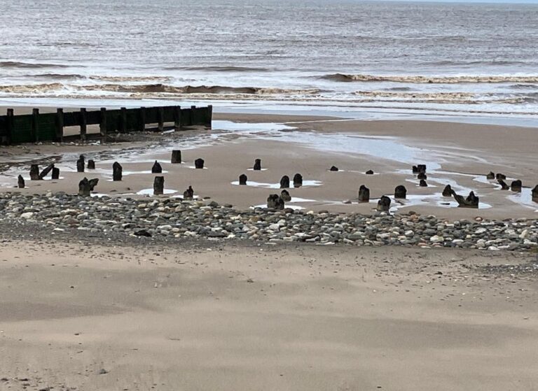
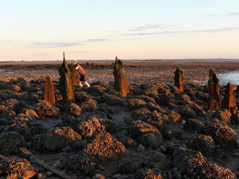
“There are the remains of another two beacons two miles further out too. This photo looks back towards the prom. One set of remains is clear in the foreground – and there’s another close behind.”
MANY THANKS to Nick Moore and his fascinating History of Blackpool, Fylde and South Wyre for some of the historical information used in this article. You can read it here
Parallel Posts at Rossall Point
Thanks to the folks of Fleetwood for providing the answer about these posts, through the Visit Fleetwood Facebook page. Revealing they were called fenders. The old (now disused) sewage discharge pipe ran between them, out to sea. The posts kept the pipe in place.

Post Tops near Rossall School
What are these wooden posts sticking up in the beach in front of Rossall School? They run at a different angle to the groyne at the left. What are they?

Thanks again to our Facebookers for providing the answer. The posts supported the discharge pipe for the swimming pool at Rossall School. A number of people added posts, remembering the swimming pool at Rossall and the discharge pipe on the beach.
Paul Long is engineer at Wyre Council. He tells us, “There’s a high concrete wall that forms part of the sea defences just north of the “tank traps”. This was the outside wall of the pool, which was demolished in the mid 1990’s”
Lawrence Houghton remembers that the pipe was cast iron, about 9 inches in diameter. He remembers walking and balancing along it many years ago. It’s purpose was in draining the pool, which filled with sea water.
Brian Jackson explains “A lot of discharge pipes were laid at an angle to the tide. This stopped back flow of sea water, when in shallow waters. Basic discharge pipes didn’t have back-flow non-return gates. In a tide surge or rough seas you could flood drainage systems inland and homes.”
Ghost of a Swimming Pool
Look carefully next time you walk along the seafront at Rossall School and you’ll see this ghost sign of the swimming pool, painted on the wall. The pool was behind the tall concrete wall between their field and the beach.

It says “NOTICE. This bath is private property. Trespassing forbidden. No responsibility taken, reliability accepted, for injury or damage arising from …. Corporation Rossall School.” Can you make out the missing words?
A Disused Gun Emplacement?
In front of Rossall School, there’s a small outbuild built into the sea wall. It’s a handy spot to sit and take a breather, while you’re enjoying a walk on the beach, believed to be an old gun emplacement and look-out point.

It links into the heritage of the big, square concrete blocks – the tank traps. Together they’re remnants of defences from World War 2. Take a look around it in the video below.

Wyre Light
Probably the best known of the Fleetwood beach landmarks, but you still need to know where to look!
Wyre Light is one of Fleetwood’s three lighthouses. They originally worked together to guide ships safely along the channel of the River Wyre.

Sadly, the Wyre Light is now worse for wear. Decades of abuse from storms, high seas, and daily tides have taken their toll and this landmark is now leaning quite badly. You can still see it though, some distance from shore, out in the bay.
Any other Fleetwood Beach Landmarks to add?
If you’ve seen something or wondered about another odd structure on the beach, send it in. All we need is a photo and rough location and we’ll see if Visit Fylde Coast readers can work out the puzzle.
You can comment below or email your suggestion to jane@theRabbitPatch.co.uk
While you’re here…
Go to the homepage of the Visit Fleetwood website for the latest updates.
Love the Fylde Coast? Sign up for your email newsletter. Packed full of interesting things it arrives in your inbox all 52 weeks of the year.
Join us on Facebook at our Visit Fylde Coast Facebook Group and follow us on Twitter @visitFyldeCoast
Plus hundreds of videos to watch on our YouTube channel – from all over the Fylde Coast!
Booking a stay? Pick a safe, clean and legal place to stay, at the very best price. Book with the Visit Fylde Coast and StayBlackpool guide.

We Need Your Help
We Need Your Help